







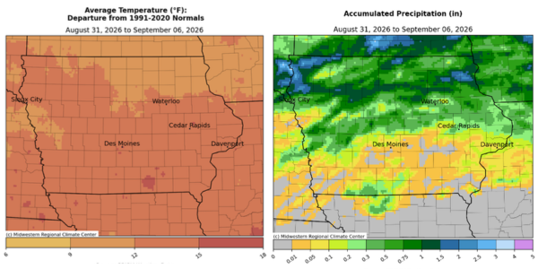
Northwest Iowa received some of the state’s heaviest rainfall last week, with Sioux Center recording 3.05 inches as farmers continued chopping silage and preparing for harvest.
The Iowa Crop Progress and Condition Report for the week ending September 6 listed the Sioux Center measurement as the state’s highest weekly precipitation total. Statewide, rainfall averaged just 0.37 inch, below the normal 0.88 inch, with several southern Iowa stations reporting no measurable precipitation.
Despite the rain, unusually hot weather dominated the reporting period. Iowa’s average temperature was 79.8 degrees, or 11.1 degrees above normal, making it one of the warmest starts to September on record.
Storms Bring Rain and Strong Winds to Northwest Iowa
Thunderstorms moved into Northwest Iowa after sunset September 1, with some becoming severe and prompting tornado warnings. No tornadoes were observed, according to the state weather summary, but Hawarden recorded an 81-mile-per-hour wind gust.
Rainfall reports from that round of storms included 1.00 inch in Orange City, 1.72 inches in Rock Rapids and 2.00 inches in Le Mars.
Storms continued across northern and eastern Iowa on September 2, with Lake Park reporting 1.12 inches. Another thunderstorm complex entered Northwest Iowa before sunrise on September 5, bringing an additional reported 1.60 inches to Rock Rapids.
The accompanying weekly precipitation map shows a broad band of heavier rainfall across Northwest and northern Iowa, with pockets exceeding two inches. Rainfall varied considerably across the region, while much of southern Iowa received substantially less.
The temperature departure map shows that Northwest Iowa also experienced above-normal temperatures, although the state’s southern half generally had the greatest departures. State Climatologist Justin Glisan said additional clouds and rainfall helped keep northern Iowa somewhat cooler.
“As we headed into the Labor Day weekend, parts of northern Iowa received much-needed rainfall that will help chip away at longer-term soil moisture deficits,” Iowa Secretary of Agriculture Mike Naig said.
Crop Maturity Trails Last Year
Statewide, 17 percent of corn had reached maturity, seven percentage points behind last year. Corn in the dent stage reached 79 percent, one point ahead of last year, while 96 percent had reached the dough stage, unchanged from a year ago.
Corn condition was rated 77 percent good to excellent.
Six percent of soybeans were dropping leaves, four percentage points behind last year. Soybean condition was rated 75 percent good to excellent.
“Farmers are busy chopping silage and preparing for harvest as we wait for corn and soybeans to dry down and fully mature,” Naig said.
Farmers had 5.6 days suitable for fieldwork, compared with 6.0 days during the same period last year. Oat harvest had largely concluded, slightly ahead of last year, and pasture condition was rated 64 percent good to excellent.
Soil Moisture Remains Short In Some Areas
Across Iowa, topsoil moisture was rated 3 percent very short, 23 percent short, 70 percent adequate, and 4 percent surplus. Subsoil moisture was rated 5 percent very short, 24 percent short, 68 percent adequate, and 3 percent surplus.
Those figures leave roughly one-quarter of Iowa’s topsoil and nearly three-tenths of its subsoil rated short or very short. The supplied crop and soil moisture figures are statewide; the report does not provide separate Northwest Iowa ratings.
Naig said outlooks indicate more seasonal temperatures and better chances of rainfall heading into mid-September.